A soils primer for Homer: Starichkof soils are the bogs and fens of Alaska
Published 1:30 am Wednesday, May 6, 2020


This is the next installment in the series “A Soils Primer for Homer.”
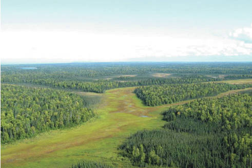
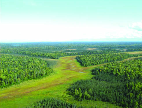
When driving north on the Sterling Highway, climbing the Ninilchik Hill, off to the right is a large meltwater stream channel. During periods of glacial melt and retreat it carried a large volume of water. Many of these remnant melt water stream channels occur across the Kenai Lowlands. Now they have small underfit streams and are occupied by Starichkof and similar organic soils. Other large areas of organic soils are in broad river valleys like the Beaver Creek flats of the upper Anchor River Valley, and the flats near Caribou Lake. In undulating topography, such as glacial deposits, organic soils commonly occupy the depressions between the moraines.
In Soil Taxonomy, organic soils are in the order Histosols. Familiar common terms are peat or muck. These soils consist of decomposed organic materials many feet thick that have accumulated under saturated conditions of wetlands. Histosols have suborders of Fibrists, Hemists, Saprists. These categories indicate the decomposition stages of plant materials and are somewhat analogous to particle size classes of sand, silt and clay in mineral soils. Fibrists have slightly decomposed plant material, Hemists are moderately decomposed and Saprists are highly decomposed. Starichkof soils belong to the Hemists suborder. A similar soil is Salamatof which is a Fibrist.
In Alaska, most folks use the term “muskeg” to identify these landforms. They are named more precisely in the literature as bogs and fens. Bogs store and release water to and from the surrounding land but are not connected to a system of lakes or streams. Fens, on the other hand, are connected to slow, but flowing water of small lakes and streams. Most of what are referred to as muskegs on the Kenai Peninsula fit the definition of fens.
The dominant vegetation communities on these soils are mosses, sedges, shrubs and black spruce. Exceptions occur where oxygenated water flows through the soil. An example is in the area of the West Homer Elementary School and the Lutheran church. Before the spruce bark beetle plague, the drive into town from the base of the Baycrest Hill was through a tunnel of huge old growth Sitka spruce forest. A robust forest generally indicates a productive, well-drained mineral soil. To the surprise of many, several feet of organic soils needed to be excavated and replaced by expensive fill material when these sites were developed. A detailed soil survey of Homer had clearly delineated these organic soils.
These soils have limited direct economic value in Alaska. Small areas are mined for peat in the horticulture industry. Subsistence berry picking is an important use in rural communities. Saprists, when drained, are important soils for specialty crops in Florida, the upper Midwest and California. Organic soils have been used for centuries as a fuel source in Scandinavia and Great Britain. In the 1960s peat accounted for 40 percent of the fuel used in electrical generation in Ireland. While this use is declining, peat is still a common fuel for home heating. Power generation using peat has been considered in remote areas of Alaska.
Possibly the most appreciated and unique industrial use of peat, on a worldwide basis, is the smokey flavor of Scotch whisky imparted by burning peat in the malting process.
The indirect economic value of these soils is huge in Alaska. Water and nutrients stored in these wetlands are released and nurture salmon fry in our river and stream systems. This is especially important during the winter to keep water flowing. The fens act as sponges in the ecosystems and absorb water during high rainfall events and release it slowly to mitigate flooding and erosion. They are also important for wildlife habitat. They offer open spaces, treasured by Alaskans, for winter recreation including snow machining, snow shoeing and skiing. ATVs have taken their toll in the summer, shredding the fragile organic mat. In recent years huge changes have occurred through the progression from hiking, to 3 wheelers, to 4x4s, and now large side-by-sides. For the protection of these fragile wetlands, it is a good practice to travel on uplands when possible. These soils provide a huge sink of organic carbon and keep carbon dioxide out of the atmosphere.
This is the last of five short articles on some of the common soils of the Homer area. Hopefully, it has been informative and provided a temporary reprieve from coronavirus news. Thanks to all of you that have provided feedback. It has allowed me to fulfill my COVID-19 imposed “community service” sentence. Don’t get bogged down. Get out in your gardens, hug your soil, and get your hands dirty.
“You can bury a lot of troubles digging in the dirt.” – Author Unknown
If you are interested in the technical details of soils a wealth of information is available from Natural Resources Conservation Service (NRCS). Soil Survey reports and maps for the Western Kenai Peninsula (Homer to Point Possession), the Lower Kenai Peninsula (Jakolof Bay to East Chugach Island), and most counties in the U.S. are also available through this link https://www.nrcs.usda.gov/wps/portal/nrcs/main/soils/survey/. The US soil survey program began in 1899 and continues today. Surveys are updated as technology develops.
Doug Van Patten, a retired soil scientist, had the pleasure of exploring, classifying, and mapping soils throughout Alaska, and parts of Montana, Hawaii, and Florida for forty years. He moved to Alaska in 1976 from Montana, worked as a soil scientist/project leader for 30 years with USDA/NRCS followed by 10 years of part-time work as a senior soil scientist with various private consulting firms including HDR Engineering and Three Parameters Plus, Inc.