‘What’s in a name?’: Reviving a forgotten past — Part 6
Published 1:30 am Thursday, March 19, 2026


AUTHOR’S NOTE: This is the sixth in a multi-part series about Kenai Peninsula places and landmarks that once had different names. Previously, the series has discussed Sterling, Soldotna, Cooper Landing, Tern Lake, and various other streams and lakes on the Kenai.
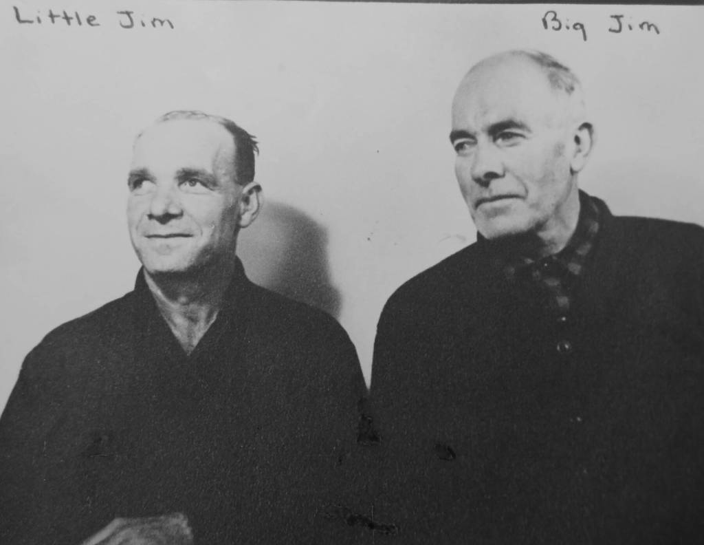
The name itself receives little attention, but the “Jim’s” in Jim’s Landing is misleading. The apostrophe implies that the landing was named for a single man named Jim, when actually it honors two close friends with that name: James (“Big Jim”) O’Brien and James (“Little Jim”) Dunmire.
The landing exists because it is a major stream-crossing leading to a trailhead. The trailhead exists because gold lies in the Surprise Creek drainage in the forested hills across the Kenai River.
The history of the landing began many years before O’Brien and Dunmire arrived in Alaska in 1935.
In the first decade of the 1900s, the upper portion of Surprise Creek was being mined by a German immigrant named Stephan Melchior, who had come north to Alaska in in the 1890s.
At some point, Melchior constructed a trail to his mine from a crossing just above the Kenai River canyon, and that crossing soon became known as Melchior’s Landing.
Melchior had mostly given up mining by 1930, and he died in Seward in 1933. The two Jims began working on Surprise Creek shortly afterward and stuck with it for three decades. By the time they retired, their name, not Melchior’s, was most closely related to the landing.
Collins Lake
In their 1957 end-of-year narrative, officials at the Kenai National Moose Range made the following note in a section entitled “Public Camp Grounds”: “The Bureau of Public Roads of the Sterling Highway via Jean Lake and north of Hidden Lake this past summer created opportunity for easy access and utilization of Jean Lake, Kelley (sic) and Collins lakes for the first time.”
Modern readers who residents of the central Kenai Peninsula almost certainly recognize the names of two of those three bodies of water. Few, if any, are likely to recognize Collins Lake.
When the Sterling Highway was first constructed in 1947, it included a nearly 20-mile stretch now known as Skilak Lake Loop Road.
Ten years after its construction, the Skilak portion of the highway was realigned to its current configuration, bringing travelers much closer to the lakes mentioned above.
Moose Range officials took advantage of the improved access: “The BPR started an access road to the last two (Kelly and Collins), part of the Seven Lake chain comprising the east fork of Moose River, but missed a turn and ended up in a bog. Aerial reconnaissance, however, revealed the feasibility and desired route for such a road, and it has high priority on the refuge program in the future. At that time, too, parking space, fire pits and sanitary facilities will be installed.”
Today, that access road leads from the Sterling Highway at about Mile 68 to Kelly and Petersen lakes and their associated campgrounds. Collins Lake was renamed at some point after 1957 and became Petersen Lake, probably at the same time that Watson Lake, across the highway, was named. Those two bodies of water were named after U.S. Fish & Wildlife Service employees James Petersen and Gerald Watson, who had drowned in Skilak Lake in the fall of 1955.
The identity of “Collins” is uncertain. Other refuge narratives around this time refer to a fisheries enforcement officer named “D. Collins,” but it is unclear whether he was the original namesake.
Mt. McCoy
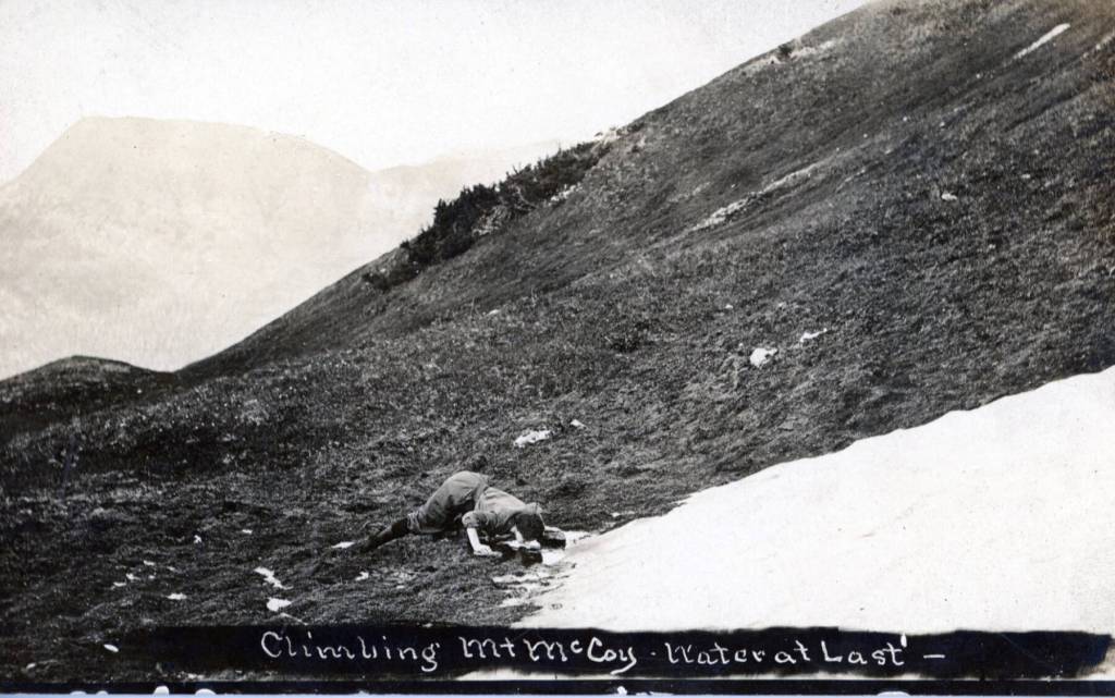
It is quite likely that this name did not exist for long—perhaps for only a year or two and probably in about 1910-12. It is also possible that the name “Mt. McCoy” never really existed, except as a joke.
A black-and-white photo postcard from this time period depicts a young person, nearly prone on a tundra-covered mountainside, drinking water, animal-like, from a small pool that had formed at the base of snow slope. Beneath the drinking figure is the title of the card: “Climbing Mt. McCoy. Water at Last.”
According to Jim Taylor, who collects historic Kenai Peninsula postcards, “It was not uncommon at the time to have personal photos put on postcard backs, most likely done at Seward. A camera had come out with a stylus, and descriptions could be handwritten by amateurs.”
Taylor said this card was likely one-of-a-kind and was created by a member of the Kenai Mining and Milling Company that was prospecting for gold on Cooper Creek.
A quick study of the mountain slope and the hazy silhouette of a mountain ridgeline in the distance reveals that the person’s thirst is almost certainly being quenched just above treeline on a Cooper Landing-area peak known today as Cecil Rhode Mountain.
Before this mountain’s name was changed to honor longtime area photographer Cecil Rhode—who, along with his photographer wife, Helen Rhode, chronicled life and wildlife on the Kenai Peninsula, and spent considerable time on the mountain that came to bear his name—it was known for decades as Cooper Mountain, after Joseph M. Cooper, often considered the founder of Cooper Landing.
After the peak was renamed for Rhode, the summit of the mountain immediately west across the Cooper Creek drainage took on Cooper’s surname, and one of the massif’s lesser rises was named for Helen Rhode.
Fort Saint George
In about 1787, a Russian named Peter Kolomin, foreman of the Lebedev-Lastochkin fur-trading company, built two log houses, surrounded by a protective stockade, along the eastern coast of Cook Inlet, about 12 miles south of modern Kenai.
According to Donald J. Orth’s Dictionary of Alaska Place Names, the site was called Saint George, “presumably for one of the ships in the company.”
Eventually, a Native fishing village grew up around the stockade.
A century later, with the Alaska Territory in U.S. hands, the population of the village was just a few dozen individuals. When and why the name of the place was changed to Kasilof is unclear, but the name Kasilof shows up on an 1842 map created by German-speaking Igor Wosnesensky, who spelled it (based on the Russian spelling) as “Kassilow.”
The spelling has varied over time—and once influenced (or was influenced by) the name of the nearby river and the immense lake at its head—but the essence of the name has remained constant for more than 125 years.
The area gained a post office in 1925, and in 1937 a crew from the U.S. Land Office, surveying for homesteading purposes on the Kenai Peninsula, found near Kasilof the remains of a partially buried village, including 31 well-preserved homes.
Vickery Creek
According to Orth, Victor Creek (which crosses the Seward Highway near Mile 20 before dumping into Kenai Lake) was previously called Victory Creek, and before that Vicory Creek, and before that Vickery Creek. It’s not difficult to imagine the reason for this progression.
In 1896, according to Mary J. Barry’s history of mining on the Kenai Peninsula, a miner named John Dana Vickery came to Hope because of the gold rush in the Hope-Sunrise area. He prospected there for two years, primarily on Bear Creek but also along Kenai Lake. Vickery then departed for Dawson, once again joining a gold rush. In 1905, he settled in Seward.
An 1896 mining article in the Alaska Search Light mentions Vickery Creek specifically several times, so it seems likely that Vickery himself had prospected on the creek by at least that year. It is also possible that Vickery had been prospecting on Kenai Lake before he went to Hope in 1896.
It is easy to envision Vickery’s name being misspelled on maps and records of the day, and thus, probably briefly, Vickery Creek became Vicory Creek. Possibly, someone believing that Vicory was a misspelling of Victory caused another name change. When it was learned that the stream had been named for one of the first miners to prospect there, it was changed, incorrectly, to Victor Creek.
Some of this progression is speculation. What is certain, however, is this: In 1908, when miner Harry Johnson was prospecting in the area and was mauled by a brown bear, the Seward Gateway referred to the stream as Victory Creek.
John D. Vickery lived out his life in Seward, dying there at age 82 in a house fire in February 1932.
NEXT TIME: THE LAST INSTALLMENT IN THIS SERIES, INCLUDING DeLONG LAKE.