A soils primer for Homer: Beluga soils get name from their water
Published 1:30 am Wednesday, April 22, 2020


This is the next installment in the series, A Soils Primer for Homer.
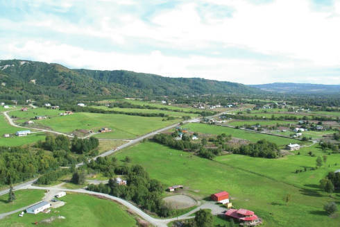
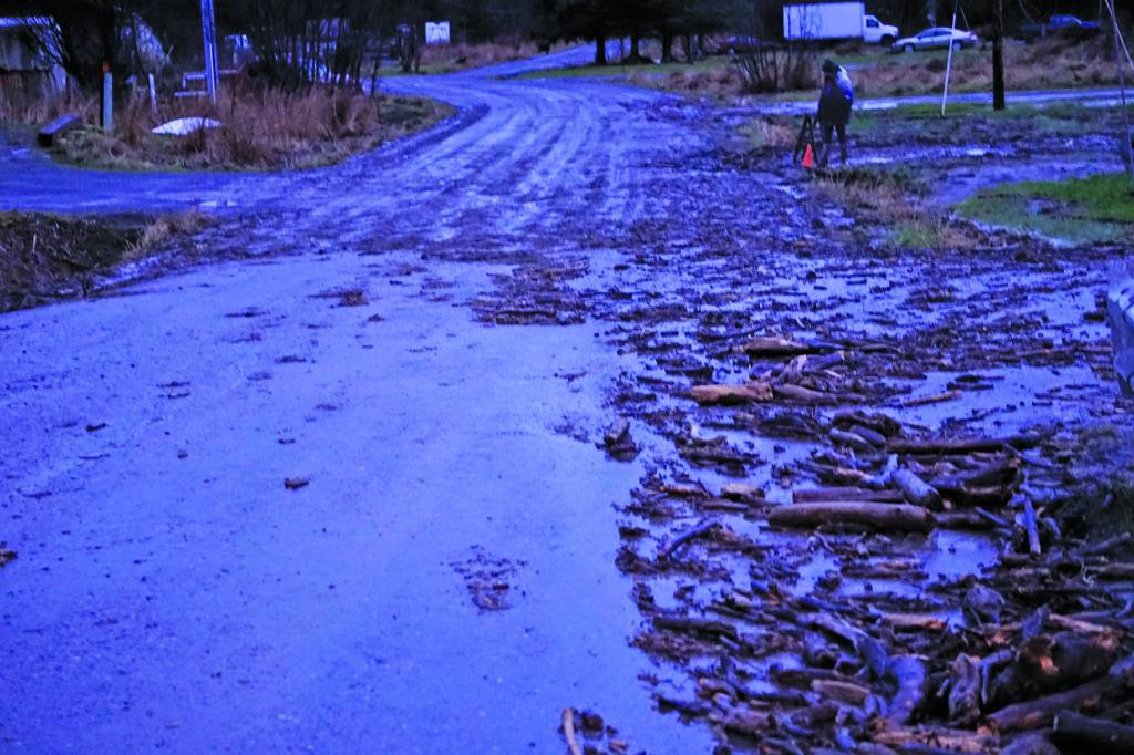
When you drive out the Homer Bench toward Fritz Creek you are in Beluga country. The Bench is a geologically active landform comprised of coalesced alluvial fans. Beluga soils also occur on the west side of the Fox River Valley including the village of Kachemak Selo. In these locations, gravity and water erosion transport material from bluff faces and canyons of the stratified Kenai formation into entrenched intermittent stream channels. During heavy rainfall events, debris dams in the channels can break, spreading a deluge of mud, chunks of coal, and woody material over the land surface. Homer’s latest depositional event was in early December 2019 at Bear Creek where it crosses East End Road.
So how did a marine mammal, the beluga, become the namesake of a soil? Dig a 1- to 2-foot-deep hole and there is your probable answer: water, and lots of it. If it is during the dry season and the soils have a gray matrix with orangish spots, they are referred to as redoximorphic features, and indicate that the soil is saturated at times. These soils become increasingly wetter moving downslope from the apex of the fan toward the toe slope.
The views, southeast aspect, and gentle slopes of the Bench override the limitation concerns of these soils for most people. Water problems can be mitigated with French drains, footer drains, surface drains, protective embankments, and other methods. But, if coal chunks and large woody debris are exposed during an excavation, and there is a steep bluff or canyon above a site, there is always a chance of another event. Leonardo da Vinci noted, “Mother Nature does not break her own laws.”
In the past, pastureland and productive hayfields were the dominant land use on the Bench. Recently, new homes seem as plentiful as hay bales. Beluga soils are relatively fertile and are slightly to moderately acid in pH. Gardeners find they are slow to drain, but the southeast aspect warms them rapidly and the effect of sub-irrigation reduces the amount of watering required during dry periods of summer. These soils are great for small ponds.
Contractors do not have a high opinion of these soils. Quite often they grumble about the “blue clay” layer of these soils. Yes, they often have substratum layers that have a clay content that gives them a texture of silty clay loam or clay loam. However, these soils are far from being a truly clay soil. It is important to differentiate between clay size particles and clay minerals. The clay found in our soils is primarily very fine rock material that has been ground down through glacial processes and deposited by slow moving water. Conversely, clay minerals are formed in soils overa long period of time through weathering processes in more temperate climates.
Soil horizons that have this accumulation of clay are called argillic horizons. In Alaska we have neither the soil forming factors of time or climate to produce argillic horizons. Perhaps people confuse silt size particles with clay? Clay has a particle size of 2 microns or less. That is the within the range of tiny droplets containing the corona virus. Your N95 mask would pass small clay particles. It is their small size and surface charge that make them very sticky when wet and hard when dry. These are properties that do not endear clayey soils to lots of folks.
The soil texture triangle is a good tool to visualize the concept of texture class names. If you know the percentages of sand, silt, and clay the texture name is displayed. Conversely, if you know the texture name, the percentages of sand, silt, and clay can be approximated. In the example given, equal percentages of sand, silt, and clay yield a texture of clay loam. Clay loam is one of the common textures of the lower layers of the Beluga soils.
A soil texture class calculation tool can be found online at
https://www.nrcs.usda.gov/wps/portal/nrcs/detail/soils/survey/?cid=nrcs142p2_054167
If you are interested in the technical details of soils a wealth of information is available from Natural Resources Conservation Service (NRCS). Soil Survey reports and maps for the Western Kenai Peninsula (Homer to Point Possession), the Lower Kenai Peninsula (Jakolof Bay to East Chugach Island), and most counties in the US are also available through this link: https://www.nrcs.usda.gov/wps/portal/nrcs/main/soils/survey/.
The US soil survey program began in 1899 and continues today. Surveys are updated as technology develops.
Doug Van Patten, a retired soil scientist, had the pleasure of exploring, classifying, and mapping soils throughout Alaska, and parts of Montana, Hawaii, and Florida for forty years. He moved to Alaska in 1976 from Montana, worked as a soil scientist/project leader for 30 years with USDA/NRCS followed by 10 years of part-time work as a senior soil scientist with various private consulting firms including HDR Engineering and Three Parameters Plus, Inc.