Scientists update Homer on new tsunami zones
Published 1:30 am Wednesday, May 22, 2019


There was some good news and some bad news when city officials, employees and emergency responders met at Homer City Hall on May 8 with Barrett Salisbury, Ph.D., an earthquake geologist in the engineering section of the state’s Division of Geological and Geophysical Surveys in Fairbanks, and Elena Suleimani, Ph.D., a tsunami modeler at the Alaska Earthquake Center in Fairbanks.
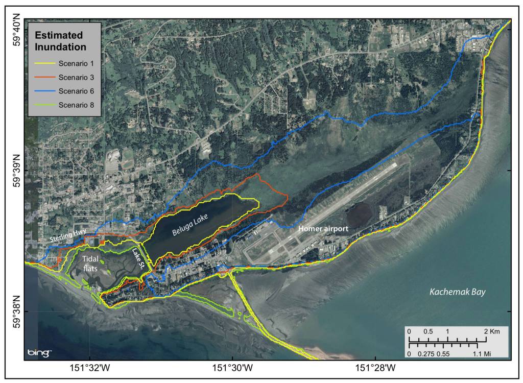
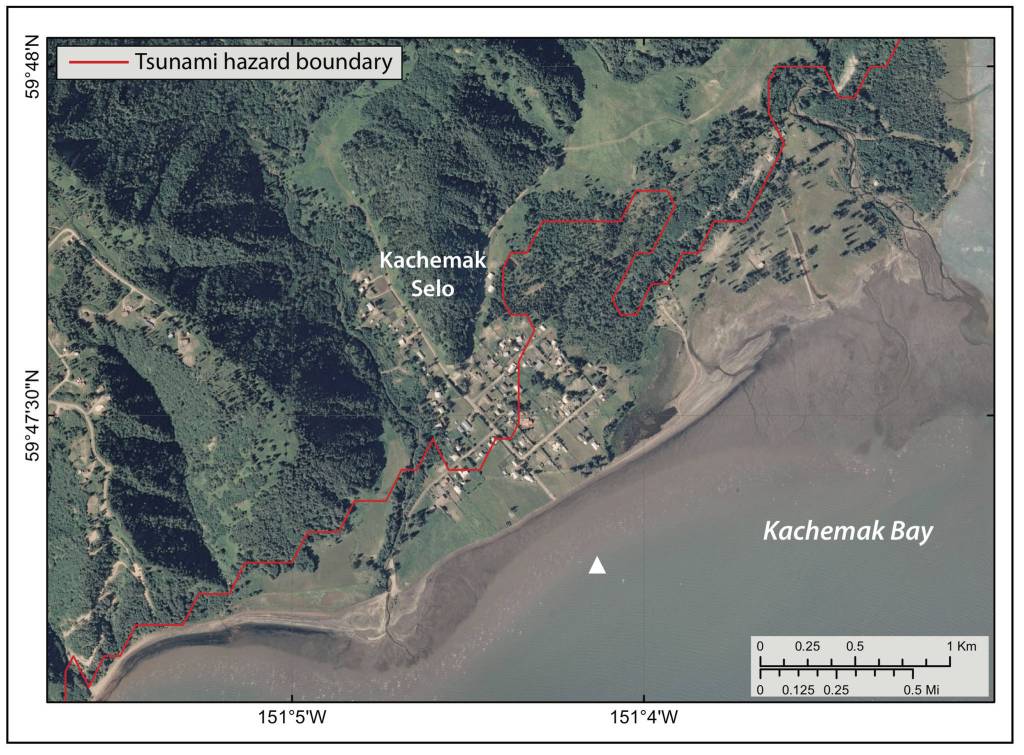
The good news was to repeat what Homer residents were told earlier this year. Unlike past directions that said anyone south of Pioneer Avenue needed to evacuate north of that line to escape the threat of an approaching tsunami, revised maps now place the blue line, or maximum inundation zone, at 50 feet above sea level — somewhere between the Homer Bypass and Pioneer Avenue. Unfortunately, that still leaves the Homer Spit and the area surrounding Beluga Lake and Slough within the zone, but it leaves a larger area out.
“These new maps are good news for many people and businesses,” said Interim Homer Volunteer Fire Department Chief Robert Purcell. “It’s helpful because we won’t have that many people to move and evacuate if they don’t need to, which lessens the burden of movement on the roads and on shelters and everything else. Now we can make a determination how to plan for that.”
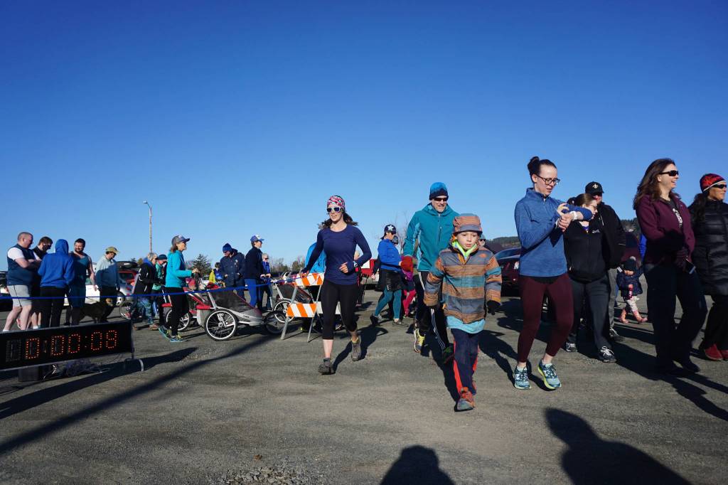
The maps and supporting data are contained in “Updated Tsunami Inundation Maps for Homer and Seldovia Alaska,” written by Salisbury, Suleimani and D. J. Nicolsky and published by the Division of Geological and Geophysical Surveys in October 2018. In March, the city’s Tsunami Awareness Week began familiarizing residents with the updated information. Maps were available to help identify areas remaining within the inundation area and a fun run/walk with a 2.66-mile course roughly followed the blue line so participants could actually see where the revised boundary has been placed.
“Our goal is to provide community-specific tsunami mitigation products that are based on the best available science, numerical tools and data,” said Suleimani.
The earth’s crust consists of about a dozen constantly moving sections, or plates. The magnitude-9.2 earthquake that shook Alaska in March 1964 occurred when the Pacific Plate lurched toward the north, under the North American Plate. That event, the second-largest earthquake recorded with modern instruments, caused water to violently splash around in the state’s rivers, lakes and bays, wreaking havoc and taking lives. The resulting tsunami caused flooding, harbor and estuary damage along North America’s west coast. Rushing up the shore at Crescent City, California, it took the lives of 12 people, bringing the tsunami’s total death toll to 122 and damage to $2.3 billion.
In Homer, more than 150 miles from the epicenter of the earthquake, the Spit bore the brunt of the damage, subsiding almost 6 feet. That drop combined with high tides resulted in flooding and a $1.6 million tab for construction and rehabilitation. In Seldovia, the ground dropped more than 3 feet, causing flooding of the picturesque boardwalk and buildings lining it, as well as one end of the airport runway. Suleimani pointed out earthquakes are only one tsunami trigger. Others include volcanic eruptions, as well as underwater subsidence and slumps, the settling and shifting of sediment. As an example, she told about an underwater landslide in Skagway in 1994 and the resulting wave that caused one death.
Modeling tsunamis allows for faster and more reliable forecasts. For the Homer and Seldovia area, modeling required a series of grids that took into account National Ocean Service hydrographic surveys measuring water depth and bottom configuration. Also used were National Oceanic and Atmospheric Administration’s electronic navigational chart soundings, a United States Army Corps of Engineers harbor survey and sonar surveys. Data used in other Alaska tsunami inundation studies also was helpful, but with only a short known history of earthquakes and tsunamis in Alaska, the scientists created multiple hypothetical earthquakes and landslides to examine different scenarios based on local geology. The depth at which an earthquake occurs also can affect tsunamis, so four different scenarios were considered: depths of 6.2 miles, 12.4 miles, 18.6 miles and 25 miles.
Suleimani also showed a video of tsunami-generated currents measuring from three to 12 knots in Kachemak Bay and around the Spit, but that study has not been finalized.
“We cover all the scenarios we think are plausible,” she said.
The not so good news came in response to a question about Homer’s geographic location making it safe from tsunamis. Salisbury’s answer was very clear.
“We are not necessarily protected here by virtue of location,” Salisbury said. “It’s going to feel like the tide is coming in, more than a regular high tide by several meters. It’s going to bounce around and continue to come in and out for at least 12 hours. The first wave is not necessarily the worst wave. Depending on the tides, it may be 11 hours or later before the biggest wave hits shore.”
That potential 11-hour window doesn’t mean there’s time to spare when it comes to evacuating, however.
“Tsunamis in Seward and Valdez happened within minutes of the earthquake beginning, during the earthquake. The wave hit the shore before the earthquake stopped,” said Suleimani, referring to the 1964 event. “We don’t have hours to evacuate. We have minutes.”
While the inundated area may seem smaller on the updated maps, there is still plenty of area below the blue line and people who live and work within harm’s way.
“It’s scary to think about for those of us that live and work on the coast,” said Bryan Hawkins, Homer harbormaster. “What concerns me is that we don’t really have a good plan. The average citizen isn’t going to spend a lot of time trying to learn everything about tsunamis. They’re relying on us to tell them what to do.”
What to do is actually pretty simple, Hawkins continued.
“When you hear the siren, you need to evacuate the lowlands. It doesn’t matter where you are — the Spit, Ocean Drive, Bishop’s Beach — when you hear the siren or when you feel the earthquake, you need to evacuate to safe ground,” he said.
For now, Jenny Carroll, special projects and communications coordinator for the city of Homer, has posted an “emergency link” on the city’s website. In includes how to be notified in case of an emergency, tsunami and earthquake awareness and preparedness, the city’s emergency plan, how to contact family and friends during a disaster, and more. In addition to educating area residents, there also is the need to ensure visitors are given information about tsunami preparedness. Hawkins and Purcell both see the need for more signage.
“Our signage is the bare minimum at this point,” Hawkins said. “We should be investing in that, working with the state, getting more signage put in and effectively marking the routes for evacuation off the Spit and out of the lowlands.”
More sirens also are needed, especially at the tip of the Spit.
“Employees in the ferry terminal can’t hear the siren,” Hawkins said. “Sirens and more signage should be right at the top of the list.”
Being above the blue line doesn’t necessarily mean it’s wise to stay place during an event, Purcell pointed out.
“People who live on Ocean Drive might technically be safe, but they might want to evacuate because a severe tsunami can isolate them and turn that area into an island, taking out the road at both ends so they have no means of egress,” he said. “This is where people need to sit down and judge for themselves what the best solution is.”
For Purcell, the decision is simple.
“If in doubt, it’s better to evacuate,” he said. “Err on the side of caution and comfort.”
Hawkins agreed.
“We can’t stop it (a tsunami). We can’t predict it. All we can do it get out of its way,” he said.
Suleimani echoed both Purcell and Hawkins.
“The point is to grab whatever kit you have prepared and go where you need to go,” she said. “People need to get it in their heads that it will happen and you don’t have tome to think about what to do.”
“There’s enough strain there to produce another 1964 earthquake,” he said of the area where the Pacific Plate and North American Plate meet. “We expect there could be earthquakes bigger than 1964 here at any time.”
For more information:
City of Homer emergency information: www.cityofhomer-ak.gov
Updated Tsunami Inundation Maps for Homer and Seldovia: dggs.alaska.gov/pubs/id/30095
McKibben Jackinsky is a freelance writer who lives in Homer.