The Killey mystery — Part 1
Published 1:30 am Thursday, May 7, 2026


Think of this article as a crowdsourcing exercise.
According to the Merriam-Webster Dictionary, crowdsourcing is “the practice of obtaining needed services, ideas, or content by soliciting contributions from a large group of people and especially from the online community rather than from traditional employees or suppliers.”
In this case, I am the solicitor, and my readers comprise the source from which I hope to benefit.
A regular reader might logically wonder why I am seeking, rather than providing, information in this space. Because I have reached a dead-end of sorts in my research, it is my intent, in this case, to do both — provide information and seek it.
The mystery
A number of years ago, while reading Peter Kalifornsky’s 1991 magnum opus, K’tl’ehg’i Sukdu: A Dena’ina Legacy: The Collected Writings of Peter Kalifornsky, I came across two place names containing the word “Kili.” The first was Kili Betnu, the Dena’ina name for Ryan’s Creek, a small, Kenai-area stream, and the second was Kili Bena, the pond forming the headwaters of the aforementioned creek.
Alan Boraas and James Kari, the editors of the book, added this side-note: “Kili is not a Dena’ina name. Peter Kalifornsky thinks it comes from a white man who lived in the area, probably the same person Killey River is named for.”
That note piqued my curiosity. If Kalifornsky was correct, and if “Kili” was the Dena’ina version of “Killey,” finding the namesake of the Killey River might be as simple as finding a white man named Killey who lived or worked in the Killey River area just prior to the time that the name Killey began to show up in print.
According to Donald J. Orth’s comprehensive Dictionary of Alaska Place Names (1967), Killey River was “a local name” reported by Fred H. Moffit, of the U.S. Geological Survey, in 1904 and contained in Moffit’s 1906 document entitled “Reconnaissance Map of the Northern Portion of Kenai Peninsula Alaska.” Orth added that one variation of the “Killey” name was “Kelley River.”
This last note added a level of complication to my search. If, by chance, the namesake had been “Kelley” and not the rarer “Killey,” it was likely going to be more difficult to find the right person — if that right person could be found at all. I decided to proceed in the belief that Moffit had been correct in his spelling; his map showed “Killey,” clearly spelled in the currently accepted way.
I began by searching for individuals named Killey who had been on the central Kenai Peninsula prior to 1904. I found one, but my information about this person was skimpy. In Mary J. Barry’s second edition of A History of Mining on the Kenai Peninsula, Alaska, she wrote that in 1895 “A.M. Killey” was one of several men to file on placer-mining locations on Palmer Creek, a tributary of Resurrection Creek, which flows into Cook Inlet at Hope.
Barry’s source for this information, according to her chapter notes, was the Turnagain Arm Mining District records, Book 1.
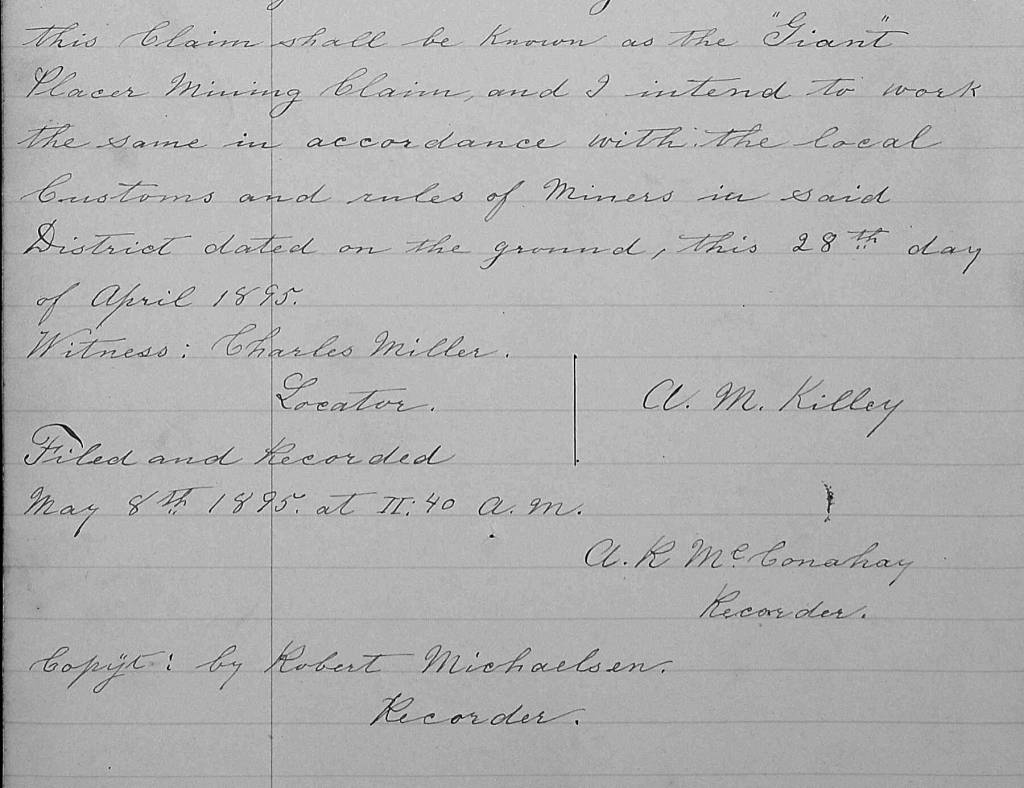
That record book revealed that a man named — frustratingly — only A.M. Killey filed on two placer-mining claims during 1895. On April 28, he filed a 20-acre claim on Resurrection Creek. He named his new claim “Giant.” On May 5, he filed another 20-acre claim, this time on Palmer Creek, and named his claim “Moose.” Beyond these two recorded notifications, I have thus far been unable to find any other Turnagain Arm references to mining actions by Killey, including records of his selling or abandoning of his claims.
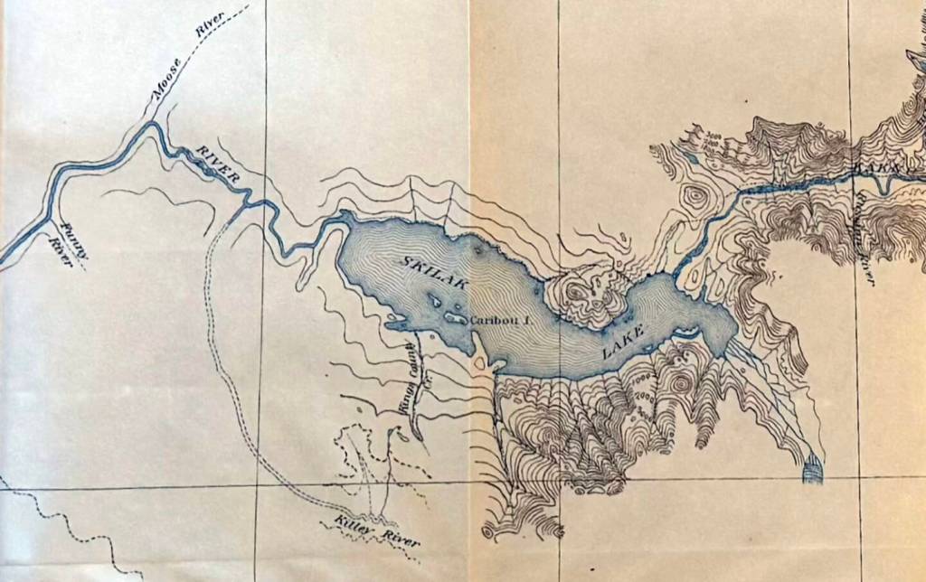
However, the records of the Lake Mining District from 1897 seem to provide another piece to the puzzle. On May 20, 1897, a group of eight men jointly located a 160-acre placer-mining claim “commencing at a corner post at the junction of Kiley [sic] creek and the Kenai River.” On this same date and over the next two days, various groups of miners filed on adjacent 160-acre placer parcels along the south bank of the Kenai River, between the Killey River and the outlet of Skilak Lake. These miners included Homer Pennock, namesake of the City of Homer.
Although the claims were staked between May 20 and May 22, they were recorded officially between June 14 and June 16. The recordings could not have been made official earlier because it was during the Lake District’s miners’ meeting of June 4 that the district legally expanded its boundaries to include the Killey River drainage. In the minutes of that meeting, the stream was referred to as the “Kiley river,” but its location was clearly the same as in the placer claims.
None of the placer claims include anyone named Killey; therefore, it seems likely that the name was already acknowledged prior to the recording of the claims. In other words, Killey himself had already come and gone.
On Sept. 6 of the following year (1898), prospector W.C. Picking, who had been penning a series of mining-in-Alaska-and-the-Yukon commentaries for the Dixon (Illinois) Evening Telegraph, supplied another entry. He wrote about a conversation he had had with William N. “Bill” Dawson, who had spent the previous four years prospecting and hunting on the Kenai Peninsula, including the Killey River, spelled as it is today.
Dawson, who lived for nearly a quarter-century in Kasilof and Kenai, had spent a number of winter trapping seasons in the Skilak area before frostbiting his feet so severely that he lost some of his toes and had to leave behind his time in the mountains.
Perhaps Dawson referred to the river as “Killey” because he had become acquainted with Alvin Killey sometime between 1894 and 1897. The Skilak area is a large, sprawling place, but Dawson traveled frequently between Skilak Lake and Kenai; their paths might have crossed.
After 1898, the mentions of the Killey River became more frequent and generally more consistent. Dall DeWeese, in 1899, wrote of hunting near the head of the “Kellie River,” and he also created an early, hand-drawn map of the country between Skilak and Tustumena lakes, including a stream he labeled as the “Keller River.”
In 1903, British big-game hunter Col. Claude Richard John Cane published a memoir about a 1902 hunt between Tustumena and Skilak. He wrote specifically about “hunting the Kelly River Mountains” for Dall sheep. Moffit’s USGS created his map in 1904, it was published in 1906, and very few references to the Killey altered the spelling after that.
However, despite narrowing the time during which the name appeared, questions remained: Was A.M. Killey the namesake of the river? If so, why? Did any hard evidence link A.M. Killey to the Killey River drainage? Who was A.M. Killey? And why did he seem to disappear from the record during the 1890s?
The clues I have gathered do indeed suggest that A.M. Killey was the namesake of the river. It’s circumstantial evidence, to be sure, but it fits. The timing is right. The identity of the man fits the actions. Even his disappearance — which enhances the seemingly ephemeral nature of his connection to the river — can be explained, if not proven.
TO BE CONTINUED….