Hitting the road: Redistricting maps to be shown in local hearings
Published 1:30 am Wednesday, September 22, 2021
The Alaska Redistricting Board is taking six proposals for reshaping the state’s electoral map on the road in a series of public meetings meant to garner public feedback.
The board’s first draft proposals were met with criticism from a variety of groups including Democratic lawmakers, Alaska Native corporations and watchdog groups, and new proposals have been drafted.
New versions of district maps were released to the Empire late Tuesday afternoon from the board. Deputy director of the Alaska Redistricting Board, T.J. Presley, told the Empire a full schedule for public meetings hadn’t been drafted.
Members of the public were allowed to draft and submit their own plans and the board has already heard several rounds of public feedback. The statement said the updated proposals will reflect maps from several state groups, including a coalition of Doyon, Ltd., the Tanana Chiefs Conference, the Fairbanks Native Association, Sealaska Corp., and Ahtna Inc.; Alaskans for Fair and Equitable Redistricting; Alaskans for Fair Redistricting and the Senate minority caucus.
The Alaska Constitution says appointments to the redistricting board shall be made without regard to political affiliation, but the majority of its members are chosen by elected officials who often belong to political parties. The board is made up of five members, two appointed by the governor. The Senate president, speaker of the House of Representatives and chief justice of the Alaska Supreme Court are allowed one each.
Board members Bethany Marcum and Budd Simpson were appointed by Gov. Mike Dunleavy, John Binkley by the Senate, Nicole Borromeo by the House and Melanie Bahnke was appointed by the judiciary, according to the governor’s office.
Adoption of the final plan is constitutionally required by Nov. 10, 2021, the statement said, and the board will now begin a public meetings tour. The dates and locations of the meetings have not yet been posted.
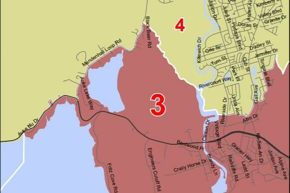
Proposed districts for Juneau
The current district lines that have been in place since 2013 put Douglas Island, downtown Juneau and Lemon Creek in District 33, currently held by Rep. Sara Hannan, D-Juneau, and also includes Haines, Skagway and Klukwan. The Mendenhall Valley and north of the ferry terminal are in District 34, held by Rep. Andi Story, D-Juneau.
Currently, the dividing line runs through the Mendenhall Wetlands State Game Refuge and cuts off along Glacier Highway close to the Alaska Department of Transportation building.
The latest versions of the districts would change Juneau’s Districts 33 and 34 to Districts 3 and 4, and would make portions of the Mendenhall Valley and Auke Bay in the same district as downtown Juneau and Douglas Island. Furthermore, it would change representation for the Northern Lynn Canal communities of Haines, Skagway and Kluckwan. Those communities would be put into a new Mendenhall Valley district bordered in parts by Jordan and Montana creeks, which created a jagged border running through parts of the valley.
Under those draft proposals, Story said she wouldn’t be in the district she currently represents. In a phone interview Tuesday, Story said that though she lives in the Auke Bay area, the draft proposals would have put her in Hannan’s district. Story spoke to the Empire before the new proposals were released, but the extension of the downtown district to Auke Bay remains in the latest versions.
“It’s very surprising to me,” Story said. “I’ve been trying to understand that better.”
Story said she hoped Juneauites would engage in the public process by submitting comments or their own proposals to Juneau’s public meeting.
“I haven’t really heard the rationale from the board why they feel there’s such a dramatic change,” Story said.
The proposed line briefly runs along Egan Drive before turning up Mendenhall Loop Road and then breaking left along James Boulevard toward the Mendenhall River, creating what Hannan called “the appendage.”
Speaking to the Empire before the latest maps were released, Hannan said she hoped the updated proposals better reflected the community.
“The geometry was strange,” Hannan said or of the previous proposal. “Until I see what those maps are, I don’t know what my district looks like.”
City and Borough of Juneau Deputy Mayor Loren Jones said at a Committee of the Whole meeting Monday night the city should ask for the ability to give the board feedback. Jones spoke to the Empire before the scheduling announcement was made, but said he hoped the city would have the opportunity to give feedback to the board as the previously proposed maps created problems in Southeast Alaska.
“I don’t find that acceptable, the map that was drawn to exclude Rep. Story’s neighborhood,” Jones said. “I’m not putting any motive (on the Board), but I think the way they’re moving things around is questionable.”
The new versions 3 and 4 for the southern Kenai Peninsula also are similar to previous versions that move the Fritz Creek area out of the current District 31, renamed District 6, and into a new District 5 that includes Kodiak Island and Prince William Sound.
Contact reporter Peter Segall at psegall@juneauempire.com. Follow him on Twitter at @SegallJnuEmpire.