
Just over 1,000 acres of land in Cooper Landing were newly classified for resource management and recreation following a vote by the Kenai Peninsula Borough Assembly in favor of the move last week.
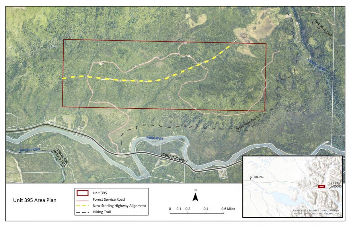
The borough-owned parcel, located just north of Cooper Landing, is also called Unit 395 and will be bisected by the Cooper Landing Bypass Project. That project aims to reduce traffic congestion through Cooper Landing by adding 10 miles of new highway starting at Milepost 46.5 of the Sterling Highway. The highway bypass will cross Juneau Creek before rejoining the highway at Milepost 56.
The borough has, for years, brainstormed what the development of Unit 395 could look like, while also fielding concerns from Cooper Landing residents, who have long made clear their opposition to certain types of development on the property.
A final master plan for the parcel, prepared by engineering consultant RESPEC and submitted to the Kenai Peninsula Borough last September, recommended that the land be classified for both resource management and recreation. The plan, prepared over the course of eight months, incorporates feedback from community members and provides additional information and context on what different types of development in the area could look like.
“Management of the parcel under these classifications should emphasize the importance of cultural preservation and facilitation, wildlife habitat and movements, and maintaining future development opportunities alongside recreation and resource extraction activities,” the plan says of a resource development and recreation classification.
Three areas of the parcel have already been identified for material extraction, including one gravel site north of the bypass site and two hard rock sites south of the bypass site. The gravel site is expected to yield up to 50,000 cubic yards of material over two years. There are no permit plans for the two hard rock sites.
When it comes to recreation, the plan offers suggestions for new infrastructure, such as hiking trails, day use facilities, public use cabins, winter motorized trails and a Nordic ski race facility. Such infrastructure, the plan says, is consistent with what the community wants and supports existing recreation opportunities in the area.
“The KPB does not have a parks and recreation department to develop these facilities at this time, but they were included in this plan to reserve space for development by future partners given the importance of recreation to not only Cooper Landing residents, but all residents of and visitors to the Kenai Peninsula,” the plan says.
The plan recommends that the borough leverage grant opportunities and local partnership to help advance recreation goals in the area.
Also included in the document is a summary of points of agreement and disagreement between people who provided public feedback, such as on housing, recreation, wildlife, access and economy. For example, residents who submitted comments generally agreed that there is insufficient housing in Cooper Landing, but they disagreed about whether housing should be developed on Unit 395.
“Three comments were fully opposed to housing on Unit 395 and three more indicated that the commenters would strongly prefer no development on Unit 395,” the plan says. “Five commenters mentioned affordable housing, with most indicating that they would prefer to see affordable housing developed closer to the existing infrastructure in Cooper Landing.”
The plan identifies residential development as a “mid- to long-term goal,” and says that affordable housing should be prioritized on other pieces of borough land closer to Cooper Landing.
The same plan identifies the Kenaitze Indian Tribe as a key stakeholder, as half of Unit 395 is contained within the Sqilantnu Archaeological District. That area, located around the upper Kenai River, contains “hundreds,” of archaeological sites and the tribe has worked with Alaska Department of Transportation and Public Facilities to ensure that artifacts and human remains are respected and preserved.
Kenai Peninsula Borough Land Management Officer Marcus Mueller told assembly members during a Jan. 16 meeting of their lands committee that Unit 395 was “poorly understood land” prior to the reconnaissance and planning work done over the last year. That work, he said, revealed that the parcel contains the westernmost hard rock resources on the peninsula’s road system.
“We haven’t taken the next steps to really prove that out and see to what degree those materials would meet the specifications for public construction of ports and harbors, but if there is hard rock there it would be a significant,” he said. “Hardrock resources are generally regional in nature.”
While there are resources in Unit 395 that are commercially viable right now, Mueller said the opportunity for residential development isn’t there yet. As a result, the plan recommends that the land be held to preserve the opportunity for future development.
“A lot of the potentials of this property just are not right right now,” Mueller said. “It’s not the time right now to go in and start plopping subdivisions up there. Whether that’s 10 years out or 20 years, I don’t have that crystal ball, but I think once the highway goes through there and people start looking at it, it’s going to drive a whole lot of new interest in that landscape that’s up there.”
More information about Unit 395 planning efforts and the final parcel master plan can be accessed at unit395planning.com.
Reach reporter Ashlyn O’Hara at ashlyn.ohara@peninsulaclarion.com.
