Refuge Notebook: Connecting fish and community to resources in Port Graham
Published 10:30 pm Tuesday, February 20, 2024


A baby salmon faces many challenges on its journey to the sea and eventual adulthood. Streams that baby salmon live in provide shelter from predators, food and conditions for optimal growth. Occasionally, these streams can become fragmented and inaccessible to baby fish due to natural or man-made obstacles.
These obstacles can be a physical blockage like a landslide or a blocked culvert in a road. Sometimes, the stream can still pass through the obstacle but at too swift of a flow or too great of a drop for baby salmon to navigate. Even adult salmon can be blocked from miles of upstream habitat by obstacles.
Identifying man-made obstacles to fish passage and determining solutions to restore habitat connectivity in Alaska is a task of the U.S. Fish and Wildlife Service National Fish Passage Program and our partners. The team works across Alaska in various habitats and watersheds, including wildlife refuges and public, private and tribal-owned lands.
In 2022, the USFWS Fish Passage Program partnered with the Port Graham Native Corporation to identify barriers to fish passage along the Port Graham Road. The road serves the community of Port Graham, a village located at the southern tip of the Kenai Peninsula, that is only reachable by airplane or water taxi and is approximately 20 miles from the town of Homer.
A permanent village was first established in Port Graham in 1896 when Unegkurmiut, or Alutiiq-speaking peoples from Alialik Bay, moved to the area. Coal extraction from the head of Port Graham Bay fueled the local economy, followed by fishing and logging. Today, the community consists of approximately 150 people, mostly of Alutiiq descent, or Sugpiaq peoples, meaning “real people.”
Traditional subsistence and cultural activities are core to the community’s identity and future. Maintaining access to their lands and subsistence resources is a high priority of the community. Like rivers providing access to resources for baby fish, roads and trails can provide people access to resources in their environment.
The 26-mile road connecting Port Graham to Rocky Bay is part of a road network built initially for logging access in the middle of the 20th century. The road connected the village of Port Graham to a wealth of Southcentral Alaska coastal habitat as recently as a decade ago.
Community members used the road to access beaches, rivers and streams for subsistence hunting and fishing. A culture camp was held in a cove on one of the many bays, and a commercial lodge was operated on Rocky Bay Lake.
About a decade ago, a series of severe winter storms wiped out key bridge crossings, and the road became overgrown and inaccessible. The lodge shut down, and the community lost access to the many resources on their lands.
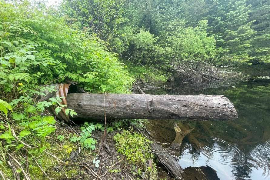
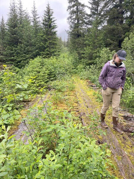
I had the opportunity to visit Port Graham in the summer of 2023 and travel the road in its current state to Rocky Bay. Tribal members guided our team in four-wheel drive trucks for the first 14 miles. The difficulties of traveling the road became immediately apparent at mile 15, where a tangle of giant, semirotten logs and debris signaled where a large bridge once stood.
The bridge at mile 15 of the road had been washed out during a winter storm in 2014, limiting travel beyond the bridge to ATV and foot traffic. It took us most of a day to travel the remaining 20 miles to the end of the road at Rocky Bay.
Our team was grateful for the work of the road crew that had cleared most of the brush from the road that previous summer. Still, multiple washouts and narrow trail sections slowed our travel.
The planned future improvements will not only allow for tribal members to access their lands more easily, but the repair of the collapsed crossings will also allow salmon to once again reach resources upstream of the road.
Over the next four years, USFWS and partners will identify, engineer and oversee the replacement of derelict, nonfunctioning culverts along the road. The Exon Valdez Oil Spill Trustees Council fund will fund these efforts, providing local individuals with jobs and training for culvert replacements and road improvement activities.
The Port Graham Corporation also received funding from the bipartisan infrastructure act and the Tribal Transportation Program to replace additional culverts and bridges along the road and some of the many spur roads in the area.
Opening the road will once again provide Port Graham community members access to their lands and opportunities for subsistence, culture camps and economic development. Similarly, baby salmon will have access to miles of upstream habitat and the resources therein for the first time in decades.
This upstream habitat will provide valuable habitat to future generations of salmon, just like the road reopening will provide opportunities for subsistence and recreation for current and future community members of Port Graham.
Sarah Aspens is a Fish and Wildlife Biologist with the Southcentral US FWS Habitat Restoration Team. You can find more information on the Refuge at http://kenai.fws.gov or http://www.facebook.com/kenainationalwildliferefuge. The Refuge Notebook is published twice a month and you can find past Refuge Notebook articles at https://www.fws.gov/kenai-refuge-notebook.