City to revise tsunami brochure
Published 10:30 pm Tuesday, May 17, 2022


At Homer City Council meetings, much of the council’s business involves discussing and considering resolutions and ordinances. At last Monday’s council meeting on May 9, the council exercised another of its duties: offering the city manager its opinion on items in the manager’s report.
So when City Manager Rob Dumouchel presented a draft brochure for tsunami awareness and evacuation areas in his report, Dumouchel got an earful, particularly when that brochure put the Homer Police Station and Wells Fargo Bank in the tsunami evacuation zone, even though a tsunami wouldn’t affect those buildings.
Several council members asked Dumouchel to revise that map — direction the city followed up on this week.
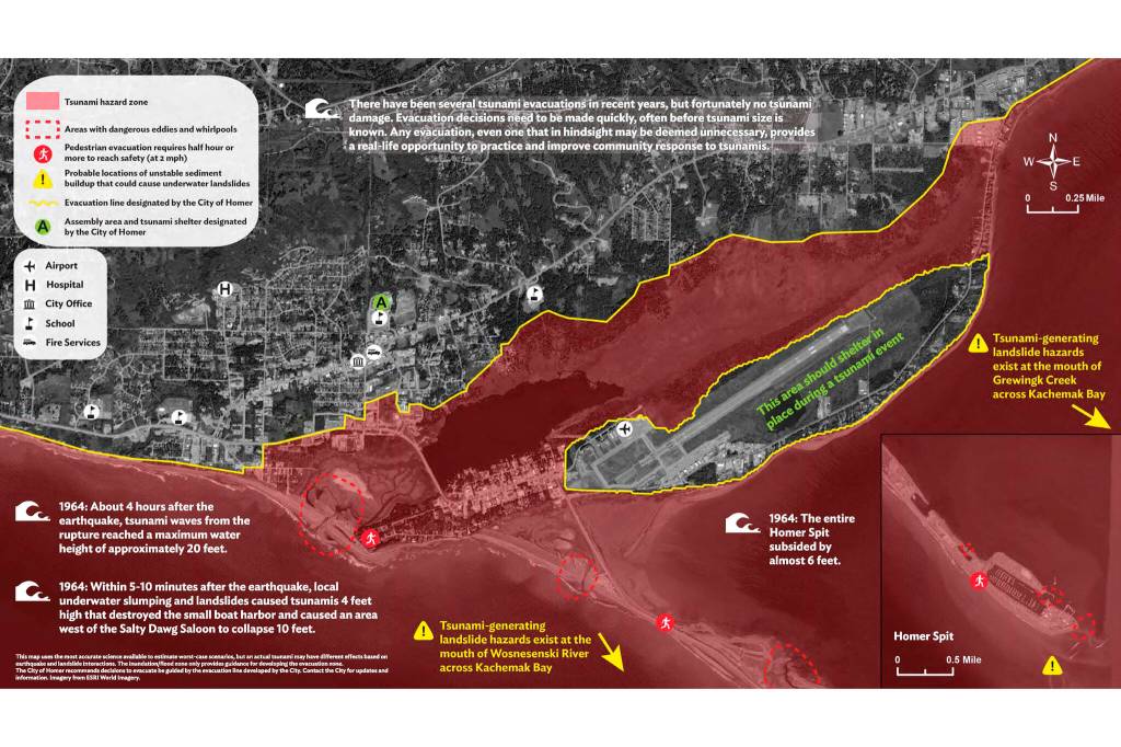
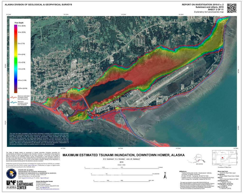
In 2018 the Alaska Geophysical Institute and the Alaska Division of Geological and Geophysical Surveys published new maps showing tsunami inundation zones in downtown Homer and the Homer Spit. Those maps put the maximum inundation zone at 50 feet above sea level to include all of the Spit and much of the area surrounding Beluga Lake and Beluga Slough. The city has held workshops and even a foot race along the 50-foot perimeter, called the Blue Line in tsunami communities, to educate residents about inundation zones.
The draft tsunami brochure follows best practices where evacuation zone borders follow property lines and roads, said Special Projects & Communications Coordinator Jenny Carroll at the meeting. In a follow-up interview on Tuesday, she said those best practices follow guidelines set by the National Weather Service in its “Tsunami Modeling and Mapping: Guidelines and Best Practices Series.”
Under those practices, the weather service advises “the evacuation zone should include a safety buffer that extends the evacuation zone beyond the modeled inundation zone (e.g., to the next street or intersection).”
The brochure has two audiences, Carroll, with two different messages, “One for people who don’t live here and one who know it very well.”
Some cities in tsunami zones have actual blue lines painted on streets to show inundation zones, but that won’t work with the wear-and-tear Homer streets get in the winter or on gravel roads. The city is talking about putting up street signs to show the blue line, though, Carroll said.
Under previous evacuation zone parameters, the city set an arbitrary line along Pioneer Avenue, even though some neighborhoods below Pioneer Avenue then and under the new maps are out of the inundation zone. The main emergency shelter, Homer High School, is well above Pioneer Avenue and East End Road, and that remains the best place to retreat in the event of tsunami evacuation order.
On the new draft brochure, the evacuation zone ran north on the lot line between Safeway and Wells Fargo to Hazel Avenue below the Homer Public Library, over to Heath Street, and above the police station along Grubstake Avenue all the way to Lake Street. It also designates areas like the Homer Airport as shelter in place zones, meaning they’re safe from tsunamis but that moving to roads away from the airport, such as FAA Drive, would lead into evacuation zones.
Including the police station in the evacuation zone didn’t sit well with the council.
“One thing that I thought was interesting is when I zoom in, that the line was drawn to include the police station which, you know, we had a conversation when we talked about putting the police station on that property, the tsunami line kind of cut across the very bottom of that property,” said council member Donna Aderhold.
Dumouchel said one reason for putting the police station in the evacuation zone is so people wouldn’t go there. People should go further uphill “because we need that space (the police station) to do emergency operations,” he said.
Council member Rachel Lord said she disagreed with that. Putting the police station in the evacuation zone would confuse people.
“I think that’s terrible,” she said. “… That rationale seems really off in terms of the amount of distress it could sow.”
Council member Shelly Erickson said she agreed with Lord. The city would get a lot of grief in the news if it showed the police station in the evacuation zone.
“We don’t need this police station to be shown in that inundation zone at all,” she said.
“I’m sensing a consensus building here,” Mayor Ken Castner said after the council comments. “I think, I would also agree there is a perception problem that you have here.”
At the meeting, Carroll asked if the council’s concerns would be satisfied if the map made clearer that it was an evacuation line and not an inundation line.
Lord said putting the police station below the evacuation line might suggest it would be evacuated.
“Does HPD intend to evacuate the site with prisoners and essential equipment?” she asked. “Because if it is drawn within an evacuation zone, then I would expect as a member of the public to see HPD evacuating that site.”
Homer Police Chief Mark Robl said on Wednesday that the police station would not evacuate in the event of a tsunami and that the station is safely out of the inundation zone.
Council member Jason Davis also asked why Wells Fargo would be in the evacuation zone while Safeway was not. Aderhold said what residents want to know is if they’re in an inundation zone.
“Well, Mr. Manager,” Castner said at the end of the discussion. “I think that you have a task and I think the council probably wants to look at it (the tsunami brochure) again.”
On Tuesday right after an interview with the Homer News, Carroll had a Zoom meeting with Elena Suleimani of the Alaska Geophysical Institute and one of the authors of the revised inundation hazard map. Carroll said Suleimani approved revising the evacuation zone around the police station and Wells Fargo. There will be some edits of the map for the council at its meeting on Monday, Carroll said.
The new evacuation zone will exclude Wells Fargo, with a line running north-south between it and First National Bank up to Hazel Avenue, east-west along the lot line between the Homer Post Office and the Homer Police Station, up Snowbird Street to Grubstake Avenue, over to Lake Street and down to below the Homer Courthouse.
Robl said that if residents need to check if their homes or businesses are in a tsunami inundation zone, they can call police at 907-235-3150 and an officer will make a visit to advise them. In the event of a tsunami, and it there’s time, police also will go to inundation zones and alert people to leave.
Reach Michael Armstrong at marmstrong@homernews.com.