
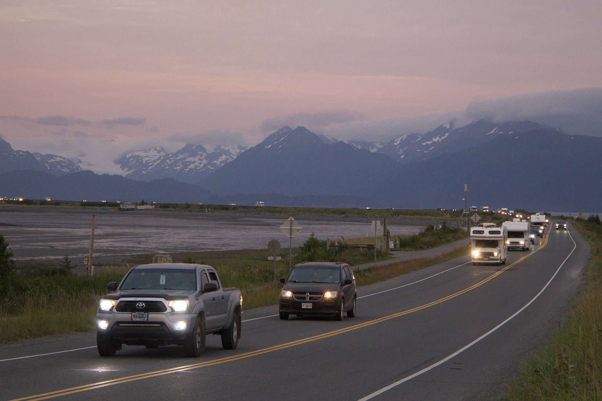
Lara Hildreth and Cindy Buchanan never expected their vacation would end in an emergency evacuation from their hotel room at Land’s End Resort because of a tsunami warning. As the warning sirens blared evacuation orders, Hildreth and Buchanan knew they needed to get off of the Homer Spit quickly.
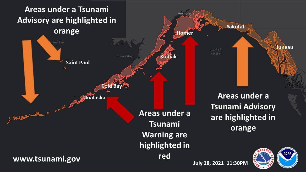
The tsunami warning was issued after a magnitude 8.2 earthquake rattled the Aleutian Island chain at around 10:15 p.m. Wednesday night, about 64 miles southeast of Perryville, according to the Alaska Earthquake Center. The quake sent shock waves through towns on Alaska’s Gulf Coast and triggered the tsunami warning in the Aleutian Islands, Kodiak, the Southern Kenai Peninsula and other towns across the state.
“When we realized we were on the Spit, which is not a great place to be when there is a potential tsunami, we took it very seriously,” Hildreth said. “… When the sirens went off, that’s when it really hit home.”
Without most of their belongings or a car in which to escape, the pair began walking until a visiting couple offered them a ride to Skyline Drive, well above Homer’s inundation level.
“I’ve been in a lot of earthquakes, but I’ve never been in a situation where it could have been so strongly tied to a tsunami in a place where you absolutely do not want to be caught in any surge of any amount of water,” Hildreth said.
Matt Clarke, the Homer deputy harbormaster, said that when he felt the earthquake, he and his team were able to help clear the Spit and ensure the boats at sea were safe.
“Within minutes we knew that it was a magnitude … of 8.1, I think, 11 miles southeast of Chignik,” he said. “Knowing the magnitude of that event and its potential to generate a wave in our relatively close proximity, that put us all on alert right away.”
Hildreth said the pair was impressed with how quickly emergency services were able to respond to the earthquake and tsunami as police officers directed traffic along evacuation routes.
Homer Police Chief Mark Robl said the station in Homer quickly began sending out all available officers as soon as the sirens went off to help people get to safety in an orderly manner. People were directed to East End Road, Skyline Drive and Homer High School until the warning was downgraded to an advisory.
“We immediately began setting up traffic control checkpoints to help with congestion and make sure traffic kept flowing smoothly,” Robl said. “The Spit was very busy last night as we’ve had a very busy summer, but I was very impressed with the evacuation. It was orderly; it was quick.”
Brenda Ballou, the city clerk for the City of Seward, said the evacuation went smoothly on Resurrection Bay as well.
“What I witnessed was a really orderly evacuation,” she said, adding that it was “not a panic moment, just an action moment.”
Police and fire officials, as well as Seward High School Principal Scott Axt, were quick on the scene, Ballou said.
The high school tsunami shelter hosted hundreds of people Wednesday night, including visitors who had to evacuate their campgrounds. Ballou said they stayed at Seward High — as well as other predetermined tsunami safe zones in town — for nearly two hours, until they received the “all clear” around 12:35 a.m. Thursday morning.
At that time, the Kenai Peninsula Borough Office of Emergency Management also issued the “all clear” in the Kenai and Soldotna areas, as the tsunami warning was downgraded to advisory status.
Ballou said there were no noticeable waves detected in Seward at or after the Alaska National Weather Service’s forecasted tsunami activity time of 1:15 a.m. Thursday morning.
According to the Alaska Earthquake Center, the Perryville quake Wednesday night occurred in the Alaska-Aleutian subduction zone where the Pacific and North American tectonic plates converge.
In a Tweet on Thursday afternoon, the center reported around 140 aftershocks in the 12 hours following the Perryville quake.
Dr. Kasey Aderhold, an earthquake seismologist at the Incorporated Research Institutions for Seismology and a Homer resident, said the earthquake was deeper along the plate interface than expected, which didn’t displace the water in a significant way but still triggered the minor tsunami wave.
“The down-going plate doesn’t slide perfectly down, (and) it’ll stick and build up stress, which is then released in a large motion or earthquake,” Aderhold said.
Small tsunami waves were still occurring near Sand Point 18 hours after the earthquake, according to Aderhold on Thursday afternoon. While she said there is no more cause for concern from the 8.2 magnitude earthquake, she encourages everyone to be prepared for the next one.
“People should use these kinds of big earthquakes as an opportunity to remind yourself that you live on a big plate boundary, an active plate boundary, and to make sure you’ve got your earthquake plan,” Aderhold said.
Since 1900, there have been eight other earthquakes magnitude seven or greater within about 155 miles of Wednesday’s rumble. It is believed that the magnitude 7.8 quake on July 22, 2020, and the 7.6 on Oct. 19, 2020, were foreshocks to Wednesday’s rattle outside of Perryville, according to the Alaska Earthquake Center.
The magnitude 9.2 earthquake on March 27, 1964, also hit in the Alaska-Aleutian Trench.
Wednesday, the center reported that the Perryville quake resulted in little impact to people and infrastructure.
“You have to take these events seriously,” Clarke said. “My suggestion is if you feel unsafe, go immediately to high ground and remove yourself from harm’s way. Don’t stick around to find out if the prediction was right or wrong.”
Reach reporter Sarah Knapp at sarah.knapp@homernews.com.
Reach reporter Camille Botello at camille.botello@peninsulaclarion.com.
Evacuation zones
In the event of a tsunami warning, officials say areas of low elevations should be evacuated.
In Homer, people should evacuate to Homer High School or higher ground. The tsunami danger zone generally runs below 50 feet in elevation. For exact locations, visit the City of Homer tsunami information website.
In Seward, Lowell Point residents are advised to move to Seward High or the Tonsina trailhead. The Lowell Point Community Center is NOT safe, as it is located inside the tsunami inundation zone. The shelter at Seward High School is open, as are gates at Lowell Canyon for vehicle evacuation. The public information line for the city’s emergency operations center is 907-224-4015.
In Seldovia, people should evacuate to Susan B. English School.
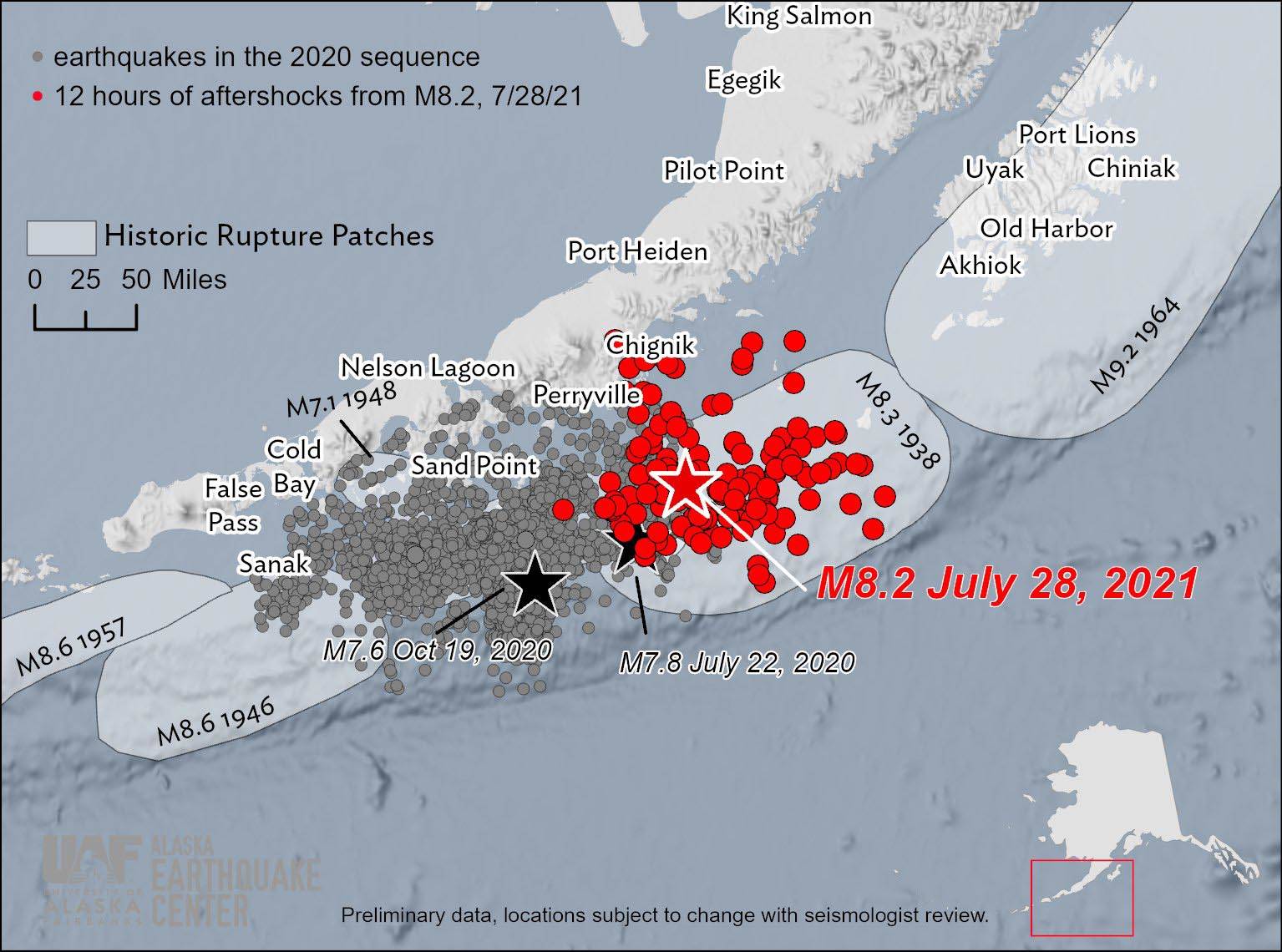
A graphic shared on the Alaska Earthquake Center’s Twitter feed shows the aftershocks of the magnitude 8.2 quake off the coast of Perryville, Alaska in red on July 28, 2021. The gray dots show the areas affected by earthquakes in 2020. (Photo courtesty of the Alaska Earthquake Center Twitter.)
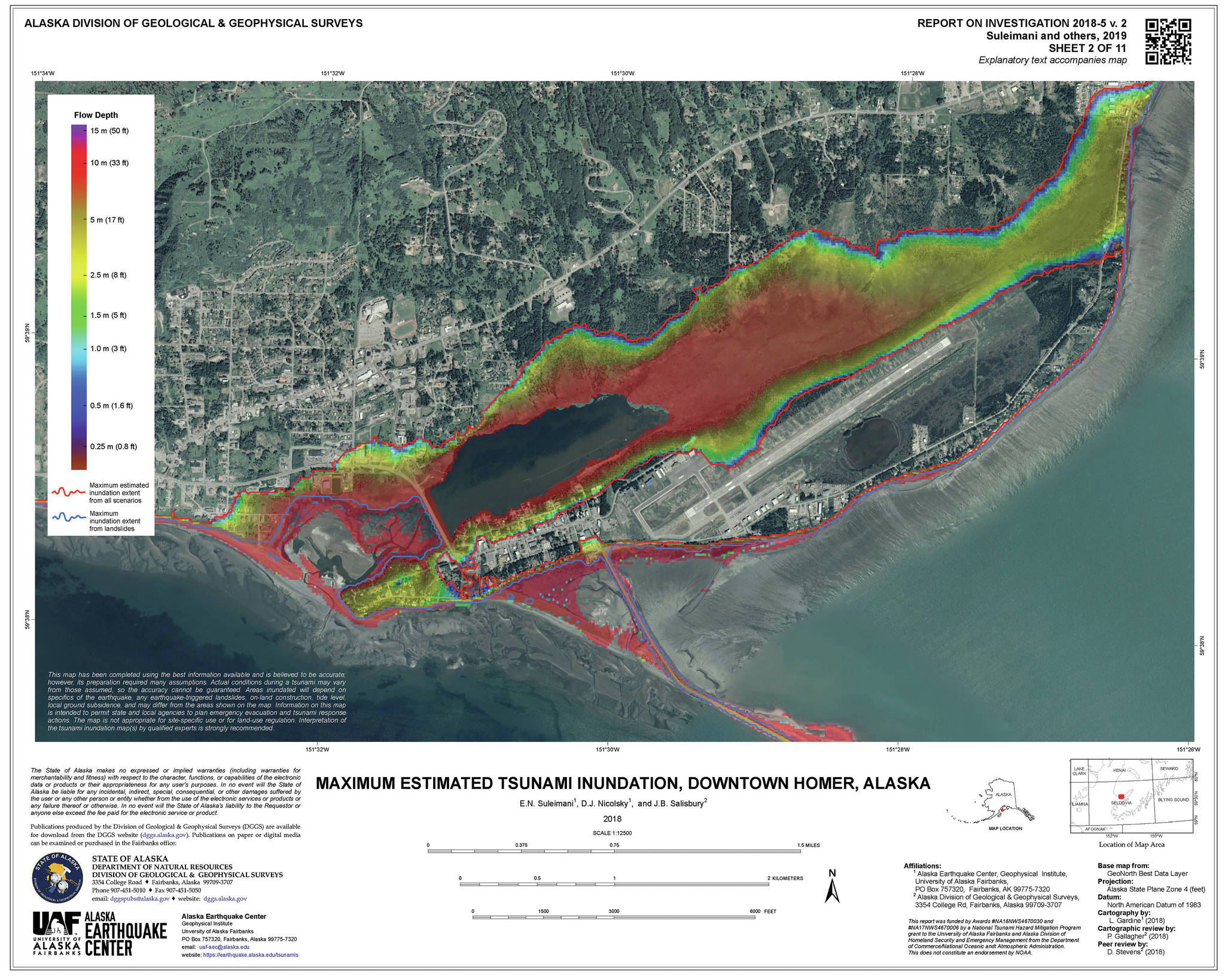
This map shows the estimated tsunami inundation zones as based on research from the Alaska Division of Geological and Geophysical Surveys. (Map courtesy of Alaska Division of Geological and Geophysical Surveys)
This map shows the estimated tsunami inundation zones as based on research from the Alaska Division of Geological and Geophysical Surveys. (Map courtesy of Alaska Division of Geological and Geophysical Surveys)
