Refuge Notebook: Landslides awakening in our glaciated mountains
Published 9:30 pm Tuesday, August 25, 2020


In 2015, a slope above Taan Fiord — an arm of Icy Bay not too far from Yakutat — suddenly collapsed. It had been creeping slowly for decades, but during a particularly rainy October, a tiny earthquake sent it careening down the slope at over 60 mph, hitting the water with enough energy to raise a tsunami that shot up the mountain on the far side of the fjord to 633 feet.
Since studying this unusual event, I don’t look at glaciated mountains quite the same way. When I see a steep slope above water, perhaps one that until recently was leaning comfortably against a great mass of glacial ice, I wonder: Will this slope fail like the one in Taan Fiord?
One of these slopes hangs over Grewingk Lake in Kachemak Bay State Park. It’s part of the drama of visiting that amazing place — a great lunk of a mountain sawed away on one side to reveal a crumbling face that seems to teeter above the water.
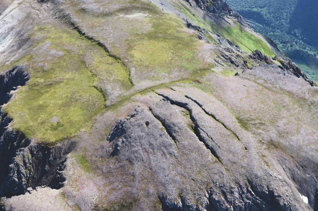
The slope has a history of failure — in 1967 it collapsed to produce a 200-foot tsunami in the lake — the 11th tallest tsunami in the past century. Farther up the ridge, where the slope is even higher and steeper than the one that failed in 1967, deep cracks stripe the tundra.
In recent years, these cracks show signs of shifting. Sediment sifts into them, hinting at new voids opening below. People, for the most part unknowingly, relax and camp on the lake’s beaches, snapping pictures of the shrinking glacier.
What can we do? I’m both a scientist who specializes in geologic hazards like this, and a hiker who loves to visit Grewingk Lake and Alpine Ridge above it. I still go there, but I don’t camp at the lake anymore — every hour spent on the lakeshore is a risk.
I want to use our knowledge of mountains like this to reduce our risk, without blanket prohibition on visiting these places. I’m working with both local scientists and collaborators all over the world to study the slopes above Grewingk.
Together, we’ve surveyed the area using a variety of techniques ranging from paddling around Grewingk Lake in a packraft with a depth sounder attached, to using state-of-the-art aerial photography to map the slopes and ridge above it.
We recently received funding to monitor it for signs of impending failure. One bright spot in this grim subject is that slopes often do show signs before they fail — they often move slowly for years, then accelerate for a time before finally collapsing. Even this “accelerated” state is not necessarily obvious, but with sensitive GPS and other instruments, we might detect it.
I’ve recently been involved in a similar but higher-profile situation in Prince William Sound. There is an unstable slope above Barry Arm, and if it were to fail it could cause a tsunami that would not only impact visitors to this wilderness, but also the town of Whittier and other more distant places.
Though it’s unsettling to discover this previously unrecognized threat, it’s good that we now recognize it, and what we’re learning there might apply to Grewingk as well.
The U.S. Geological Survey Landslides Program, and the National Tsunami Warning Center, as well as a wide array of agencies and academic institutions, have gotten involved. They are working to figure out how to monitor the slope and how to work together in order to issue a warning should it suddenly fail.
As I was writing this, I became aware of yet another potential landslide-generated tsunami risk, this one in the mountains near Skilak Lake within Kenai National Wildlife Refuge. Like Barry Arm, this risk was identified by chance observation, rather than systematic geologic study.
Across Alaska, climate change is driving retreating glaciers that have left many places vulnerable to landslide-generated tsunamis like what happened in Taan Fiord and Grewingk Lake. Most we know nothing about. We should work to change that.
Modern satellite imagery provides useful data for identifying potential unstable slopes, but hasn’t been examined for most of Alaska. Such remote analysis can be followed up by careful fieldwork and monitoring instrumentation. If we do this right, we can greatly reduce the chance of disaster while still enjoying the amazing and rapidly changing lakes and fjords of Alaska.
Bretwood Higman lives in Seldovia, where he studies geologic hazards, leads a volunteer trail-building effort in Kachemak Bay State Park, analyzes shipping accidents for Nuka Research and Planning, and helps run Ground Truth Alaska, a science education nonprofit. Find more Refuge Notebook articles (1999–present) at https://www.fws.gov/refuge/Kenai/community/refuge_notebook.html